Updated on 2023/04/13
Route - La Arena Beach and other walks through Muskiz
Description
Sitting on the edge of the Bay of Biscay, Muskiz is located at the westernmost tip of the province of Bizkaia and in the River Barbadún valley.
This coastal town is set in a captivating landscape.
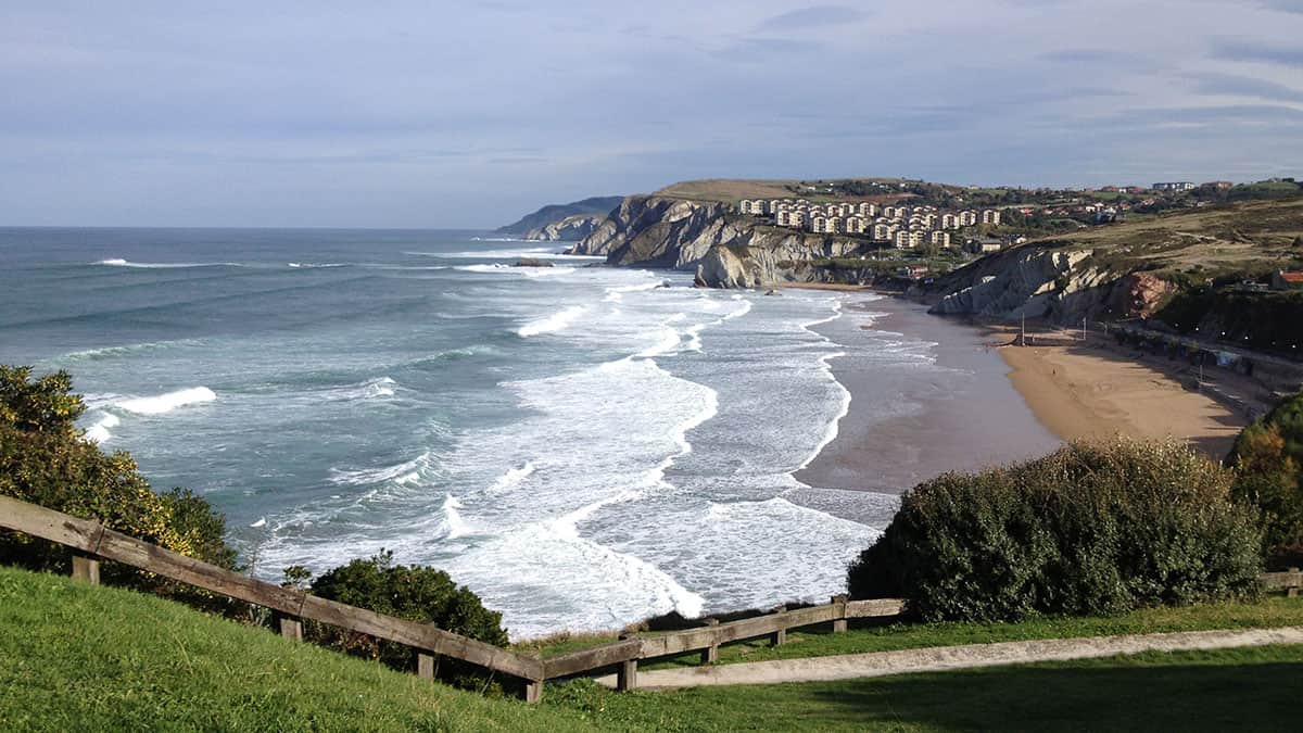
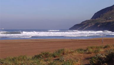
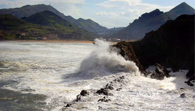
Muskiz, with kilometres and kilometres of coastline, noted for La Arena beach and the steep cliffs, is home to real natural delights such as the Itaslur park and a beautiful cliff-top walk between Kobarón and Pobeña along the coast. Muskiz also has many charming and very interesting spots.
Not for nothing is it known for its great wealth of cultural heritage, boasting different stately buildings. Muñatones Castle is a splendid building from the Middle Ages that will take you back to that time. The compound, consisting of a castle, a palace and chapel, was declared a Historical-Artistic Monument in 1944.
El Pobal forge, an interesting historical site
The El Pobal forge is worth visiting, as the building is brimming with history. It dates back to the 16th century and typical tools used in the forge can be seen there. You then visit the tower-house of the same name standing just beside it. The main frontage has an arched doorway and the coats of arms of the Quadra lineage.
Muskiz has a busy year-round calendar of festivities. The patron saint's festivities are around St. John's Day at the end of June. But the town is well known for its Carnival, held in February. Finally, the agricultural fair in September that is very important locally warrants special attention.(Euskadi.eus)
This coastal town is set in a captivating landscape.
Muskiz, with kilometres and kilometres of coastline, noted for La Arena beach and the steep cliffs, is home to real natural delights such as the Itaslur park and a beautiful cliff-top walk between Kobarón and Pobeña along the coast. Muskiz also has many charming and very interesting spots.
Not for nothing is it known for its great wealth of cultural heritage, boasting different stately buildings. Muñatones Castle is a splendid building from the Middle Ages that will take you back to that time. The compound, consisting of a castle, a palace and chapel, was declared a Historical-Artistic Monument in 1944.
El Pobal forge, an interesting historical site
The El Pobal forge is worth visiting, as the building is brimming with history. It dates back to the 16th century and typical tools used in the forge can be seen there. You then visit the tower-house of the same name standing just beside it. The main frontage has an arched doorway and the coats of arms of the Quadra lineage.
Muskiz has a busy year-round calendar of festivities. The patron saint's festivities are around St. John's Day at the end of June. But the town is well known for its Carnival, held in February. Finally, the agricultural fair in September that is very important locally warrants special attention.(Euskadi.eus)
Highlight
- Coastal seascape
- Dunes and marshes
- Cantabrian holm oak forest
- Reed beds
How to get here
By bus (BIZKAIBUS):
- A2336 Muskiz - UPV/EHU (direct)
- A3321 Portugalete-Zierbena-La Arena-Muskiz
- A3323 Portugalete-Muskiz-Galdames
- A3334 Santurtzi-Muskiz-Zalla-Balmaseda
- A3335 Muskiz-Zierbena-Sestao
- A3336 Bilbao-Muskiz (Ortuella)
- A3338 La Arena-MUSKIZ-BARAKALDO-Areeta/Las Arenas
- A3339 Gurutzeta/Cruces-Barakaldo-La Arena
- A3340 Bilbao-Abanto and Ciervana Abanto Zierbena-Muskiz (A-8)
BY CAR:
- From the A8 highway: Take the Muskiz or Gallarta/Zierbena exit
BY TRAIN - METRO UNDERGROUND-BUS
- Renfe C-1 suburban line
Route
Muskiz (Biscay)Section 1
From the car park at the Somorrostro football pitch to the San Julian de Muskiz neighbourhood
Not suitable for people with reduced mobility (PRM)
Walk that begins at the Somorrostro football pitch car park and ends at the San Julian de Muskiz neighbourhood crossroads . This route takes you along the bank of the River Barbadún. Despite the natural wealth there, the first part of the route from Muskiz is quite narrow and not suitable for bikes, which makes it difficult for wheelchair users. It is also hard to reach the start of the walk in a wheelchair.
Description of the section and its accessibility level
- Section length
- 1,60 km
- Pavement
- PVC fencing, compact aggregate and tarmac.
- Obstacles
-
- Potholes in the tarmac
- Less than 150 cm wide at the start of the route.
- No lowered pavements to reach the path.
- No pavement, use hard shoulder.
Equipment for receiving the external resource on the section
- Is there reception equipment on the section?
- No
Outdoor space: Parking areas and access to equipment
- Is there a parking area?
- No
- Are the access slopes suitable for people with reduced mobility?
- No
- Are there railings and/or handrails?
- No
Indoor space: General features
- Are the access slopes suitable for people with reduced mobility?
- No
Personal care area
- Are there personnel trained in accessibility in the facilities?
- No
Rest zone
- Is there a rest area at the reception?
- No
Store
- Is there one or more stores at the reception?
- No
Children’s area
- Is there a children’s area at the reception?
- No
Exhibition room
- Is there an exhibition room at the reception?
- No
Exhibition Hall
- Is there an exhibition hall at the reception?
- No
Interpretive equipment
- Are there trails on the section?
- Yes
Access
- Is there lighting at night?
- No
- Minimum accessible connection between parking spaces, if any, the start of the obstacle-free trail
- Yes
- Is there an adequate slope to allow circulation without assistance, with personal assistance or with technical assistance?
- Yes, without assistance from third parties
- Parking spaces reserved for vehicles used to transport disabled people according to current regulations. At least 5% of the total spaces
- Yes
- Parking signage, if any, with the International Accessibility Symbol on the floor and/or on walls
- No
- Informative poster at the start of the trail indicating the length, route, difficulty, duration and slopes by sections
- No
- Path start sign positioned no higher than 195cm
- No
Itinerary
- Vertical start signage
- No
- Compact, non-slip and with no projections along their entire length, allowing wheelchair transit
- The road is compact along the trail, but it does have bumps.
- 2 m. paved trails with non-deformable and non-slip material, with a different texture and different from the rest
- No
- The route is more than 150cm wide, with occasional narrowings of 90cm
- No
- Minimum clearance height of 220 cm
- Yes
- Rest areas
- No
- Urban furniture (fountains, dispensers...) arranged along the pedestrian route to provide sound orientation
- No
- Guiding partition and/or tactile foot signs to draw attention to an important feature
- Yes
- Islands with a minimum width of 150 cm to facilitate two wheelchairs passing each other
- Yes
- Is there an adequate slope to allow circulation without assistance, with personal assistance or with technical assistance?
- Yes, with no assistance
- Unevenness through pedestrian routes
- No
- Tree branches do not obstruct the route at below 2.20 m
- No
- Ramps, bridges and walkways with more than 50cm of unevenness, 90cm handrails and with handrails at two heights: 65-75 cm and 95-105 cm
-
No
This section has handrails on one side and, on the other side, trees planted along the whole route and acting as a natural barrier. 20-cm high plinths along both sides of the path. - Route length dimensions and time
- 1.79 km and 16 minutes
Cycle touring lane
- Does the section have a cycle touring lane?
- Yes
- Is there adequate lighting?
- Yes
- Concrete paving, compacted and board
- Yes
- Width of 150cm on one-way tracks and 220cm on two-way tracks
- No
- 200cm clear height
- Yes
- Adequate signalling of maximum speed and dangerous crossings
- Yes
Lookout and observatory
- Is there a lookout or observatory on the section?
- No
Educational Facilities
Nature classroom
- Is there a nature classroom on this section?
- No
Recreational facilities
- Is there a recreational area on this section?
- No
Access
- Is there an adequate slope to allow circulation without assistance, with personal assistance or with technical assistance?
- No
Beaches
- Is there a beach on this section?
- No
Reviews
There are still no reviews. What are you waiting for to submit your review?